Development of the Soweto Virtual Environment

Throughout 2014, Gregory Lord (Hamilton/DHi Lead Designer and Software Engineer) and Kevin Xiao ’15 (Hamilton/DHi Student Intern) began to design and implement the early version of the Soweto Virtual Environment.  This work doubled as both an active DHi development project, as part of the Dangerous Embodiments grant (funded by the NEH, partnered with the University of Arkansas, and later University of Mass., Amherst), and as a student training and development project, training Xiao in the use of 3D modeling and game design tools.

Xiao participated in the project as a 3D modeler and scene designer for the Soweto virtual environment, learning the fundamentals of 3D modeling over the course of his participation in the project, studying under Lord.

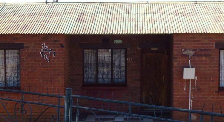
To develop this model, researcher and project director Angel David Nieves, Ph.D., provided the development team with blueprints for a variety of houses that comprise the represented section of the Soweto township, along with the Orlando Methodist Church.  Using this data, Xiao and Lord designed 3D models that used these blueprints, making sure to capture both the layout and dimensions of each building.  From there, the team used a combination of both historical and modern photographs and images to texture the houses, bringing them closer to a photorealistic appearance.

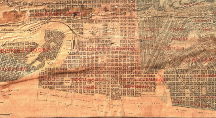
Finally, the team imported each of these models into the Unity engine, where they combined the models with tools that allowed them to create an accurate street map from Open Street Maps data.  By putting all of these together, and reconciling the building locations with maps of the region, the team recreated an accurate representation of a particular block of the Soweto township, serving as proof of concept for what will later be the full township.

First Look: Social Justice History Platform

We’re proud to offer a first glimpse at the upcoming tool for the Soweto Historical GIS Project — a 3D mapping and historical recreation platform built on the versatile Unity 3D engine:

The Social Justice History Platform is a software platform designed to represent geographic and spatial data within an enhanced interface designed to contextualize locations and objects alongside the primary source documents that provide their historical narrative, and a range of related multimedia objects (including video, audio, images, and text).

This platform is built on the Unity engine, and is currently in closed testing.  See our first video of the SHGIS platform in action below.

Recent Unity build for Soweto

Developing a User Interface (UI) layer for the Soweto Historic GIS project opens up a wide range of opportunities to integrate contextual information into the 3D virtual environment we have started to build around the township of Soweto in Johannesburg.

In this most recent version, we began to make use of Unity’s new interface system (uGUI) to add features including:

  • Displaying names of regions or buildings when the user enters their boundaries
  • Associating 2D map data (at both the city and building scales, contextually) with the user’s current location
  • Showing contextual information in a scrollable text panel on the side of the screen
  • Adding a playable/pauseable video panel to zones that have related video information

We are also excited to continue developing advanced versions of these features, including:

  • An interactive photo gallery viewer, associated image slideshows with the user’s current zone
  • A scrolling, time-synced transcript, building off of previous DHi software currently employed in the Creative Japanese Film Archive

These features will help make our large store of archival data more directly available to the user, without having to leave the 3D space in order to browse our repository.  We hope this allows for both deeper delving into the locations users are particularly interested in, and also the chance to discover new areas, and their unique histories, as they explore the space in 3D.

We expect this new interface layer, and the features listed above, to be integrated into our live SHGIS demo by late February, 2016.

Logo for “Space and Place in Africana/Black Studies: An Institute on Spatial Humanities Theories, Methods and Practice”

Sharing a copy of our new logo for the NEH Institute for Advanced Topics in the Digital Humanities.

neh_institute_space_place_logo

Gregory Lord and I worked to develop this logo in just a few hours.  Thanks to Kim Gallon (Purdue)  for being so agreeable and collegial with allowing us to “run with it,” so to speak.  Kim and I are developing a great partnership as Co-Directors on this NEH award.  Can’t wait to finally meet her in-person at the meet-up on Friday, Sept. 25th at NEH ODH in Washington, DC.

Working With Student Research Partners/Collaborators

Gregory Lord provided the following summary about our work with undergraduate research partners/collaborators:

Working with DHi’s Lead Designer and Software Engineer, Gregory Lord, DHi intern Kevin Xiao ’15 participated in the Soweto Historical GIS Project as a student modeler and virtual environment artist. Over the course of his internship, Lord taught Xiao basic 3D modeling skills within Blender (www.blender.org), an open source 3D modeling software, which Xiao was then able to apply and further develop during an extended DHi research project. Working with materials provided by Nieves, Xiao was able to use blueprints and architectural drawings to model accurate recreations of the traditional homes of the Soweto township in Johannesburg, South Africa, including the iconic Mandela Family Museum. These models were then able to be imported into the Unity engine (www.unity3d.com), to be assembled into a virtual recreation of a portion of Soweto, based on maps constructed from Open Street Maps data. The end result is a virtual recreation of several city blocks of Soweto, incorporating realistic homes and local buildings. Xiao worked on this project over the course of two years, under the instruction of Lord and the project direction of Nieves. Xiao was particularly interested in learning 3D modeling and game development tools for his independent research, and this project served as a practical example of the workflows of each type of software.

The project team is currently working to develop a qualitative 3D GIS platform for the geospatial visualization of testimony of the Soweto Uprising for wide public use.

IMG_0341

Nieves Awarded Second NEH Grant for Advanced Topics Institute


Nieves-NEH

From the NEH website:

The Office of Digital Humanities is happy to announce three awards from our Institutes for Advanced Topics in the Digital Humanities program from our March 2015 deadline. These awards are part of a larger slate of 212 grants just announced by the NEH.

Purdue University (West Lafayette, IN 47907)
Space and Place in Africana/Black Studies: An Institute on Spatial Humanities, Theories, Methods and Practice
Project Director: Kim Gallon (Purdue University)
Project Director: Angel David Nieves (Hamilton College)
Outright: $245,299

To support: A three-week summer institute and a follow-up workshop for 20 participants to explore spatial approaches to Africana Studies. The institute would be hosted by Purdue University and the follow-up workshop would be held at Hamilton College.